Monitoring the Indonesian Throughflow

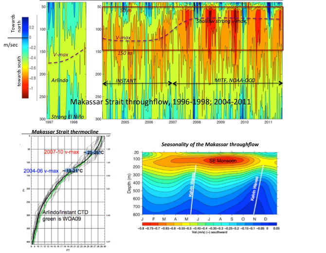
In 2008/09 the Makassar Strait throughflow profile changed dramatically: the thermocline velocity maximum increased from 0.7 to 0.9 m/sec and shoaled from 140 m to 70 m, advecting much warmer water (transport weighted temperature ~17°C). ENSO induced change of the South China Sea (SCS) throughflow drawn from the Luzon Strait is the likely cause, as increased SCS throughflow during El Niño forces buoyant SCS surface water into the northern Makassar Strait, inhibiting tropical Pacific surface water injection from the Mindanao current.
The archipelago between Southeast Asia and Australia, the only tropical interocean pathway, offers a maze through which warm Pacific water spreads into the Indian Ocean, the Indonesian Throughflow (ITF), influencing large-scale oceanic heat and freshwater inventories. As the ITF region is at the nexus of ENSO (El Niño/La Niña Southern Oscillation) and the Asian monsoon phenomena, it is highly likely, as indicated by model studies, that the ITF impact on SST patterns affect ENSO and monsoon behavior. Recording the ITF is a cost effective way to monitor a core element of the ocean and climate system, with the goal to enable improved climate predictive capability. As Makassar Strait is the pathway for 80-85% of the total ITF, it is the obvious focus of an ITF monitoring array.
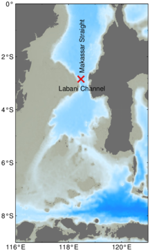
The Makassar Strait throughflow time series, at 2°51' S; 118°28' E; 2147 m, in the Labani Channel 45 km wide constriction of Makassar Strait, began with NSF funded Arlindo program in 1996-1998, and continued with NSF funded INSTANT 2004-2006 (November) and NOAA OCO 2006 (December), with the most recent recovery in August 2011, but not re-deployed due to logistical complications. The mooring was deployed on 5 August 2013, after a two-year gap in the time series.
The time series of the Makassar Strait throughflow, which carries ~80% of the total ITF and ~90% of the ITF within the thermocline, has revealed some startling changes in the ITF, which may have large scale significance to the ocean and climate system, with possible improvement in long term (interannual) predictions.
In 2008/09 the profile of the Makassar Strait throughflow changed dramatically (Gordon et al. 2012): the characteristic thermocline velocity maximum increased from 0.7 to 0.9 m/sec and shifted from 140 m to 70 m, advecting much warmer water into the Indian Ocean. ENSO induced change of the South China Sea (SCS) throughflow drawn from the Luzon Strait is the likely cause. Increased westward Luzon Strait throughflow during El Niño forced buoyant SCS surface water into the northern Makassar Strait, inhibiting tropical Pacific surface water injection from the Mindanao Retroflection; during La Niña SCS throughflow is reduced to near zero, allowing increased surface water leakage from the Mindanao Retroflection. We find that commensurate with the change in the ITF profile, there is a change in the development of the Kuroshio off the east coast of Luzon. During La Niña there is greater injection of tropical Pacific water from the North Equatorial Current Bifurcation into the Kuroshio. As the Luzon Strait westward La Niña throughflow is reduced to near zero, it is free to fully project into the Kuroshio recirculation cell of the western subtropical North Pacific. During El Niño the Kuroshio recirculation cell is 'isolated' from the North Equatorial Current Bifurcation. During El Niño the increased western throughflow in Luzon Strait drains the Kuroshio recirculation gyre waters, thus exporting the accumulated tropical water input during the previous La Niña phase. Besides the impact on the Pacific Ocean the Indian Ocean also is affected, with La Niña warmer and stronger ITF leads to warmer sea surface temperatures in the eastern tropical Indian Ocean within 2 years. Such an ‘ocean-bridge’ would linking the Indian Ocean to ENSO. Warmer SST within the eastern tropical Indian Ocean can affect the strength of the Asian Monsoon and induce a negative Indian Ocean Dipole, and perhaps have an impact on Madden-Julian Oscillation.
The NOAA OCO project is a cooperative program between the Lamont-Doherty Earth Observatory of Columbia University and the Agency for Marine & Fisheries Research (Balitbang KP), Ministry of Marine Affairs and Fisheries, Indonesia.